项目
社区
新闻
我的应用程序
我的地图
地图 成吉思市
高级搜索
全部
私人
收藏夹
Karte der Reichsgrenze zwischen Russland und China
1874
1:8 500 000
Tibet, Tartary, and Mongolia, their social and political condition, and the religion of Boodh as there existing, etc
1851|Prinsep, Henry Thoby
Das eigentliche China in 18 Provinzen
1859|Locher; Gross, Rudolf
Übersichts-Karte von Ost-Hoch-Asien
1839|Grimm, J. L.
1:12 760 000
Thibet, Mongolia, and Mandchouria.
1851|Tallis, J. & F.
1:19 008 000
Karte von China und Japan
1843|H.B.
Das Chinesische Reich und das Kaiserthum Japan
1830|entworfen und gezeichnet von C. F. Weiland
1:10 666 000
1600
1650
1700
1750
1800
1850
1900
1950
2000
历史
成吉思市的老地图
在历史地图上发现 成吉思市 的过去
成吉思市的老地图
在历史地图上发现 成吉思市 的过去
探索地图
发现历史
母区域
肯特省
相关地点
© MapTiler
© OpenStreetMap
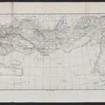 18741:8 500 000
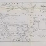 1851|Prinsep, Henry Thoby
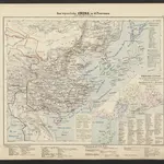 1859|Locher; Gross, Rudolf
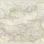 1839|Grimm, J. L.1:12 760 000
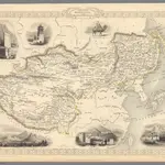 1851|Tallis, J. & F.1:19 008 000
 1843|H.B.
 1830|entworfen und gezeichnet von C. F. Weiland1:10 666 000