项目
社区
新闻
我的应用程序
我的地图
地图 威廉王子縣
高级搜索
全部
私人
收藏夹
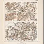
Planche XXVII. Bristow Station (Virginie). Manassas Gap (Virginie). Brandy Station (Virginie).
1875|Le Comte de Paris
1:80 000
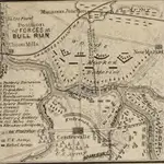
Map of the Position of Forces at Bull Run
1861|L. Prang & Co.
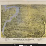
Balloon View of the Battle-ground between Washington, Manassas Junctn. & Fredericksburg.
1861|L. Prang & Co.
Map of the Battle Ground, showing 5 mile distances from Washington
1861|L. Prang & Co.
Map Of N. Eastern Virginia And Vicinity Of Washington
1862|U.S. War Department, Topographical Engineers
1:63 360
Wisconsin in the War of the Rebellion; a history of all regiments and batteries the State has sent into the field, etc. [With portraits.]
1866|LOVE, William de Loss D.D
Culpepper County
1859|L. V. Buchholts
1:322 169
1600
1650
1700
1750
1800
1850
1900
1950
2000
历史
威廉王子縣的老地图
在历史地图上发现 威廉王子縣 的过去
威廉王子縣的老地图
在历史地图上发现 威廉王子縣 的过去
探索地图
发现历史
母区域
弗吉尼亚州
相关地点
地点
費爾法克斯 (維吉尼亞州)
地点
馬納薩斯 (維吉尼亞州)
地点
馬納薩斯帕克 (維吉尼亞州)
城镇
匡提科
© MapTiler
© OpenStreetMap
 1875|Le Comte de Paris1:80 000
 1861|L. Prang & Co.
 1861|L. Prang & Co.
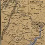 1861|L. Prang & Co.
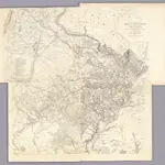 1862|U.S. War Department, Topographical Engineers1:63 360
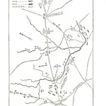 1866|LOVE, William de Loss D.D
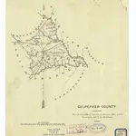 1859|L. V. Buchholts1:322 169