Project
Community
News
My App
My maps
Maps of La Selle-en-Coglès
Advanced search
All
Private
Favorites
34. Ille et Vilaine. Rennes (Bretagne)
1842|Rivaux, Auguste
Dept. D'Ille et Vilaine.
1856|Levasseur, Victor.
1:580 000
Atlas et Géographie de la France, etc
1864|LA BRUGÈRE, de Geographer
Manche.
1869|Migeon, J.
1:172 410
Dept. De La Mayenne.
1856|Levasseur, Victor.
1:571 000
Cherbourg
1838|Herder, Bartholomew
1:500 000
V.1:1-5: I: Frankreich. DEP: 30. Der Ille-Vilaine. 36. Der Mayenne. 37. Der Sarthe
1825|Hermann, O.
1:400 000
1600
1650
1700
1750
1800
1850
1900
1950
2000
History
Old maps of La Selle-en-Coglès
Discover the past of La Selle-en-Coglès on historical maps
Old maps of La Selle-en-Coglès
Discover the past of La Selle-en-Coglès on historical maps
Explore Maps
Discover History
Parent places
Arrondissement of Fougères-Vitré
Related places
© MapTiler
© OpenStreetMap
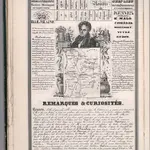 1842|Rivaux, Auguste
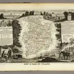 1856|Levasseur, Victor.1:580 000
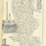 1864|LA BRUGÈRE, de Geographer
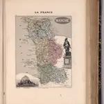 1869|Migeon, J.1:172 410
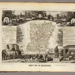 1856|Levasseur, Victor.1:571 000
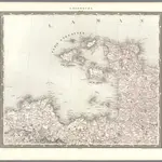 1838|Herder, Bartholomew1:500 000
 1825|Hermann, O.1:400 000