Project
Community
News
My App
My maps
Maps of Kutná Hora
Advanced search
All
Private
Favorites
Geographische Karte über die Kuttenberger Gebirgsformation zwischen Mattin, Hlisov, Gang, Grunta, Bittan, Malleschau, Politschan und Křesetitz
1849|Krehan, Joseph
1:7 000
Österreichische Nord-West Bahn
1850|Wien : [Verlag nicht ermittelbar]
Strassen-Uibersichts- und Militair-Routen-Karte des Königreichs Böhmen
1847|Marco Berra
1:580 400
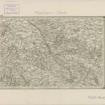
Eisenbahn Karte Wien-Dresden, Ollmütz-Trübau
1850|Minarzik, Anselm
1:72 000
Umgebungen von Chrudim
1869|K.K. Militaerischen Geographischen Institute
II. vojenské mapování 21
1871
1:144 000
Kolínský vikariát
1850
1600
1650
1700
1750
1800
1850
1900
1950
2000
History
Old maps of Kutná Hora
Discover the past of Kutná Hora on historical maps
Old maps of Kutná Hora
Discover the past of Kutná Hora on historical maps
Explore Maps
Discover History
Parent places
Kutná Hora District
Related places
© MapTiler
© OpenStreetMap
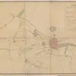 1849|Krehan, Joseph1:7 000
 1850|Wien : [Verlag nicht ermittelbar]
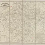 1847|Marco Berra1:580 400
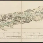 1850|Minarzik, Anselm1:72 000
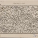 1869|K.K. Militaerischen Geographischen Institute
 18711:144 000
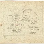 1850
1850